


ORION Voting District, Fulton County, Illinois
About
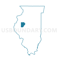
Outline

Summary
| Unique Area Identifier | 570932 |
| Name | ORION Voting District |
| County | Fulton County |
| State | Illinois |
| Area (square miles) | 36.83 |
| Land Area (square miles) | 36.47 |
| Water Area (square miles) | 0.36 |
| % of Land Area | 99.01 |
| % of Water Area | 0.99 |
| Latitude of the Internal Point | 40.58622950 |
| Longtitude of the Internal Point | -89.93188050 |
Maps


Graphs
Select a template below for downloading or customizing gragh for ORION Voting District, Fulton County, Illinois


Neighbors
Neighoring Voting District (by Name) Neighboring Voting District on the Map
- BANNER Voting District, Fulton County, IL
- BUCKHEART 1 Voting District, Fulton County, IL
- CANTON 14 Voting District, Fulton County, IL
- CANTON 15 Voting District, Fulton County, IL
- CANTON 3 Voting District, Fulton County, IL
- CANTON 4 Voting District, Fulton County, IL
- CANTON 9 Voting District, Fulton County, IL
- FARMINGTON 3 Voting District, Fulton County, IL
- LOGAN 1 Voting District, Peoria County, IL
- TIMBER 1 Voting District, Peoria County, IL
- TIMBER 2 Voting District, Peoria County, IL
- TRIVOLI 1 Voting District, Peoria County, IL
Top 10 Neighboring County Subdivision (by Population) Neighboring County Subdivision on the Map
- Canton township, Fulton County, IL (15,703)
- Farmington township, Fulton County, IL (3,350)
- Logan township, Peoria County, IL (3,192)
- Timber township, Peoria County, IL (2,511)
- Buckheart township, Fulton County, IL (1,484)
- Orion township, Fulton County, IL (1,195)
- Trivoli township, Peoria County, IL (1,021)
- Banner township, Fulton County, IL (373)
Top 10 Neighboring Unified School District (by Population) Neighboring Unified School District on the Map
- Canton Union School District 66, IL (18,091)
- Farmington Central Community Unit School District 265, IL (8,217)
- Illini Bluffs Community Unit School District 327, IL (5,662)
Top 10 Neighboring State Legislative District Lower Chamber (by Population) Neighboring State Legislative District Lower Chamber on the Map
Top 10 Neighboring State Legislative District Upper Chamber (by Population) Neighboring State Legislative District Upper Chamber on the Map
Top 10 Neighboring 111th Congressional District (by Population) Neighboring 111th Congressional District on the Map
Top 10 Neighboring Census Tract (by Population) Neighboring Census Tract on the Map
- Census Tract 49.02, Peoria County, IL (4,872)
- Census Tract 40, Peoria County, IL (4,524)
- Census Tract 49.01, Peoria County, IL (3,740)
- Census Tract 9529, Fulton County, IL (3,243)
- Census Tract 9537, Fulton County, IL (2,505)